Compliance Checker Methodology

How the Compliance Checker identifies forest-risk producing countries, builds EU member-state risk profiles, and develops the case studies and corporate analyses linking commodity flows to forest clearance and social impacts.

Last updated: 27 October 2025

Commodity trade data analysis

AidEnvironment analyses the trade flows of 77 unique commodity products (some cover an entire section, such as Chapter 47 for wood pulp), aggregated in 7 commodity groups (soy, cattle, rubber, coffee, cocoa, palm oil, wood), that originate from non-EU countries and are placed in the EU market through one or more of the EU Member States. The selection of the products is based on the list of commodities/products covered under Annex 1 of the original text of the EU Regulation on deforestation-free products (EUDR). Raw trading data is extracted from Eurostat’s reference database for detailed statistics on international trade in goods. Data for the full year can only be downloaded with a delay of about 2-3 months in the new year. Eurostat’s database is regularly updated and new versions are published monthly. The last update of the data occurred on 2026-06-15T11:00:00+0200. The dataset extracted was customized from the dataset on EU trade since 1988 by HS2-4-6 and CN8 (online data code: DS-045409). The customized dataset used in the analyses had the following characteristics: • Product: data referring to all the 77 HS codes under the scope of the EUDR were downloaded. • Partner countries (non-EU suppliers): out of the 282 countries, 219 countries were selected. All EU Member States, their overseas territories, and countries and territories not specified for commercial or military reasons were excluded, as well as Antarctica. • Reporter countries: 27 EU Member States (AT, BE, BG, CY, CZ, DE, DK, EE, EL, ES, FI, FR, HR, HU, IE, IT, LV, LT, LU, MT, NL, PL, PT, RO, SE, SI, SK). • Period: full previous year. • Flow: Imports • Indicators: Volume (in 100kg).
Development of EU member state risk profiles

Since 2021, AidEnvironment is compiling EU27 trade data, turning it into a user-friendly visualization on our Compliance Checker website. For each EU member state we analyse the trade flows between the member state and its non-EU trading partners for the 77 products covered, demonstrating: • An overview of the total EU imports of all 77 products, distributed per commodity group, from non-EU supplier countries, both in MT and value (euro). For each product a minimum threshold of 0.1% of the volume for that product is used; • An overview of the most imported product per commodity group by each of the EU Member States; • The proportional shares of each of the products in relation to the total imports of their respective commodity group. Additionally, the respective proportions (%) of these imported volumes in relation to the total non-EU import volume are also provided; • An overview of the origin of the top-5 largest non-EU supplier countries of each product, flagging the countries that been identified as forest-risk countries. We included pie charts displaying the percentage of imports of the most imported products (out of the 77 included) from the top-5 non-EU suppliers. The five most imported products were selected based on the commodity groups that, as a whole, represented the biggest share of imports to the Member State at stake out of the 7 commodity groups considered. To highlight potential high deforestation risks, we have included a “deforestation icon” next to the non-EU supply countries represented in the pie charts where these risks have been identified. See section on on how these countries have been identified. As a final remark, it must be noted that there are not always five countries listed/displayed. In the cases in which this happens, that is because 1) fewer than five countries comprised the total imported volumes supplied or received, or 2) the relative proportions (%) of the volumes are insignificant (less than 1%). The same applies to commodity products, if the product was not imported, it is also not shown in the visuals.

Non-EU producing countries with deforestation risk

AidEnvironment identified an initial longlist of non-EU commodity supplying countries with potential deforestation risk to include in the Compliance Checker, based on a range of criteria, including the presence of intact (primary) forests, net forest loss, and relevant commodity production. The criteria are a combination of the FAO definitions of forest, and a selection of risk assessment criteria under Article 10 of the EUDR:

  • Country has presence of ‘forests’ in its territory and produce relevant commodity or product, with ‘forests’ as defined by the FAO and the EUDR. The forest definition will also include parts of the Cerrado and Chaco biomes in Latin America, as well as wooded savannas and woodlands in Africa, based on FAO’s definition of ‘open forests’. Moreover, priority is given to countries with ‘primary forests’, which are a fundamental priority for conservation under FAO definitions and the EUDR. Finally, countries with ‘secondary forests’ (often degraded) are also included, which are ‘forests’ (by definition), and can also still contain high canopy cover (>10%) and biodiversity.
  • The prevalence of deforestation or forest degradation in the country, region, and area of production of the relevant commodity or product.

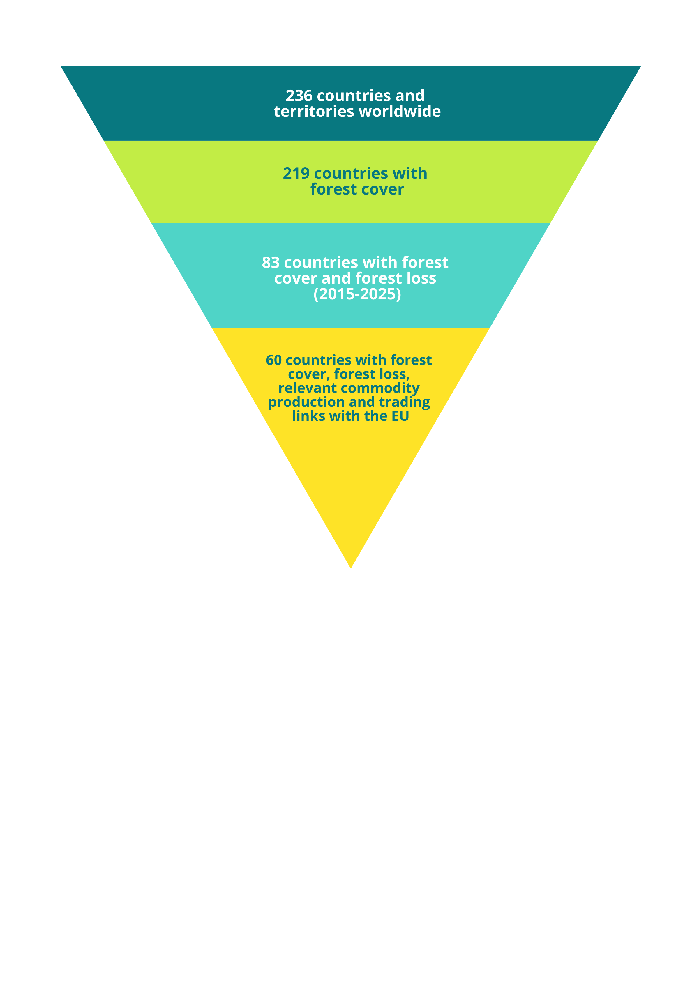
AidEnvironment has used the FAO’s Global Forest Resources Assessment (FRA) 2025 to prepare a long list of countries that would fall under these definitions. The report included 236 countries and territories in the FRA 2025, based on the list used by the United Nations Statistics Division. For each country, forest area (2025) and forest loss (2015–2025) were assessed. Based on the criteria ‘presence of forests’ and ‘prevalence of deforestation’, 83 countries were selected in the long list. To assess relevant commodity production in this long list of countries, we have used FAOSTAT production data. This would guarantee that we only include a country for commodity-linked deforestation if the commodity is also actually produced in that country. Moreover, we have used European trade statistics (Eurostat) for assessing trading links between the producing country and the EU. The evaluation of actual commodity production and existing trading linkages with the EU27 countries, reduced the longlist of 83 countries to 62 countries with deforestation risk linked to relevant commodity production. As a threshold for forest cover, we have set (an arbitrary) 200,000 hectares, resulting in excluding two more countries (Singapore and Israel), leaving us with 60 remaining countries.

Still, some challenges remain in the identification of high-risk countries based on the aforementioned criteria. Countries such as Australia, Ghana, Philippines, Viet Nam, and India would not be included based on the criteria since the country self-reports no net forest loss. Instead, these countries report an increase in forest area. However, based on more detailed deforestation-risk analysis, AidEnvironment is aware of commodity-linked forest loss in Australia, e.g., for beef. Ghana is historically linked to high deforestation-risk linked to cocoa expansion. Agricultural expansion as well as logging have had a significant impact on the deforestation in Philippines from 1980 – 2020. Rubber and coffee are attributed to the forest loss in Viet Nam, as well as recent palm oil expansion in India. Apart from their link to deforestation, these five countries export large amounts of these commodities to the EU, a reason to include them in the list of countries. While the same reasoning may apply to other countries, AidEnvironment did not do a full risk assessment for each country to understand the drivers of deforestation.

List of Non-EU commodity producing countries with deforestation risk
CountryForest area (1,000 ha) (2025)Forest Loss (%) (2015–2025)Commodities' production (2023)**
Angola63,262-0.77(S), (B), (L), (P), (C), (CF)
Argentina46,598-0.39(S), (B), (L)
Bangladesh1,873-0.05(S), (B), (L), (R)
Belize1,277-0.85(S), (B), (L), (C), (CF)
Bolivia54,370-0.42(S), (B), (L), (C), (CF), (R)
Brazil486,087-0.59(S), (B), (L), (C), (P), (R), (CF)
Burkina Faso3,237-3.10(S), (B), (L)
Cambodia6,333-3.29(S), (B), (L), (CF), (R)
Cameroon19,143-0.74(S), (B), (L), (C), (P), (CF), (R)
Central African Republic45,095-0.10(B), (L), (C), (P), (CF), (R)
Chile1,442-0.41(B), (L)
Colombia59,457-0.25(S), (B), (L), (C), (P), (CF), (R)
Congo21,854-0.03(B), (L), (C), (P), (CF), (R)
Côte d'Ivoire3,774-1.63(S), (B), (L), (C), (P), (CF), (R)
DRC139,189-0.20(S), (B), (L), (C), (P), (CF), (R)
Ecuador12,310-0.40(S), (B), (L), (C), (P), (CF), (R)
Equatorial Guinea2,407-0.34(B), (L), (C), (P), (CF)
Ethiopia26,747-0.01(S), (B), (L), (CF)
Gabon23,555-0.03(S), (B), (L), (C), (P), (CF), (R)
Guatemala3,536-0.38(S), (B), (L), (C), (P), (CF), (R)
Guinea4,857-1.28(B), (L), (C), (P), (R), (CF)
Guinea-Bissau2,100-0.02(B), (L), (P), (R)
Guyana18,377-0.05(B), (L), (C), (CF)
Honduras5,861-1.07(S), (B), (L), (C), (P), (CF)
Indonesia95,969-0.10(S), (B), (L), (C), (P), (R), (CF)
Iraq693-0.91(S), (B), (L)
Japan24,908-0.01(S), (B), (L)
Laos13,036-0.25(S), (B), (L), (CF), (R)
Liberia6,327-1.06(S), (B), (L), (C), (P), (CF), (R)
Madagascar9,922-1.16(S), (B), (L), (C), (P), (CF)
Malaysia18,885-0.30(B), (L), (C), (P), (CF), (R)
Malawi2,032-1.86(B), (S), (L), (CF)
Mali10,497-0.91(S), (B), (L)
Mexico66,266-0.19(S), (B), (L), (C), (P), (CF), (R)
Mozambique32,243-0.79(S), (B), (L), (CF)
Myanmar27,095-1.01(S), (B), (L), (R), (CF)
Namibia8,043-0.01(B), (L)
Nicaragua4,781-0.45(S), (B), (L), (C), (P), (CF)
Nigeria17,130-0.71(S), (B), (L), (C), (P), (CF), (R)
Panama4,615-0.07(S), (B), (L), (C), (P), (CF)
Papua New Guinea34,029-0.04(B), (L), (C), (P), (CF), (R)
Paraguay14,297-1.34(S), (B), (L), (P), (CF)
Peru67,160-0.35(S), (B), (L), (C), (P), (R), (CF)
Republic of Korea6,279-0.09(S), (B), (L)
Republic of Moldova370-0.42(S), (B), (L)
Senegal8,649-0.18(S), (B), (L), (P)
Sierra Leone2,436-0.78(B), (L), (C), (P), (CF)
Solomon Islands2,514-0.03(B), (L), (C), (P)
Sudan21,980-0.76(B), (L)
Surinam14,674-0.11(B), (L), (P)
Thailand19,647-0.21(S), (B), (L), (C), (P), (CF), (R)
Timor-Leste1,054-0.11(S), (B), (L), (CF), (C), (R)
Trinidad and Tobago226-0.19(B), (L), (C), (CF)
Tunisia687-0.25(B), (L)
Uganda2,368-1.12(S), (B), (L), (C), (CF)
United Republic of Tanzania43,400-1.02(S), (B), (L), (P), (CF), (C)
Vanuatu907-0.26(B), (L), (C), (CF)
Venezuela47,088-0.17(S), (B), (L), (C), (P), (CF)
Zambia44,874-0.19(S), (B), (L), (CF)
Zimbabwe13,766-0.38(S), (B), (L), (CF)

Source: AidEnvironment, based on Global Forest Resources Assessment (FRA) 2025, FAOSTAT 2023 production data, and 2024 EU trade statistics. S=Soy, B=Beef, L=Leather, P=Palm oil, CF=Coffee, C=Cocoa, R=Rubber.

Selection funnel from global countries to high-risk set based on forest cover, forest loss, production and EU trade links
Selection funnel of countries with forest cover, forest loss, relevant commodity production (soy, beef, leather, rubber, cocoa, coffee, and palm oil) and EU export — Sources: Global Forest Resources Assessment (FRA 2025), FAOSTAT 2023 production data, and EU trade statistics 2024.

Identification of key exporters and importers

AidEnvironment identifies relevant commodity producers, exporters, and importing operators from various sources, including customs shipment records, companies' third-party supplier lists, bills of lading, and transaction invoices. This data is advantageous for identifying key value chain actors because it is based on recent and hard evidence-based data, not on modelling. However, the data also has limitations, as for instance available customs shipments records vary in coverage, have non-uniform time spans, and are generally not publicly available, nor free to access. Moreover, shipment data needs to be seen as a sample and not as a dataset covering the entire trading flows between producing and consumer countries, for instance, because relevant exporters and importers might be part of traded volumes under logistical companies or the reported volume by shipment data might represent only part of the total volumes traded (e.g. over land). Despite these limitations, this evidence-based data is necessary to improve transparency in global commodities supply chains.

For supply chain mapping, AidEnvironment uses the following classification for confirmation of buyer–supplier trading supply chain linkages. In the event of multiple companies linked to one case, we emphasise the strongest relationship. All sources used and responses by the companies are included in the Compliance Checker cases.

Confirmed

  • Producers/traders/operators confirm the relationship
  • Transaction invoices
  • Animal transportation data (GTA) confirms the direct trading relationship (beef/leather)
  • Company supplier lists (e.g. public palm oil mill lists, cocoa or soy supplier lists)
  • Conab trading subsidy programs (Brazil)
  • Publicly available insurance data (e.g. coffee)
  • Detailed shipment data (all commodities)
  • Notary acts / company-registry profiles (e.g. on oil palm concessions)
  • Traders have assets (warehouses) within the boundaries of the property
  • Company management reports or other relevant public evidence (e.g. fiscal records, tribunal cases)

Probable

  • Confirmed trading relationship with the corporate group, but not necessarily with the property under investigation
  • Animal transportation data (GTA) confirms an indirect trading relationship (beef/leather)

Potential

  • Beef processor is a leading commodity exporter in the municipality (e.g. Trase)
  • Commodity traders have assets (silos, slaughterhouse) within a radius of 50 km from the property

Corporate analysis and company grouping

After downloading raw shipment data, the next step is cleaning the data, which includes grouping exporting and importing companies into company groups. Grouping companies requires doing targeted research on the relevant entities to understand their corporate structure, including on their subsidiaries and possible affiliations, as well as their role in the supply chain (e.g., producer, logistical company, commodity trader, downstream company). For this, AidEnvironment resorted to different strategies, depending on the commodity/sector at stake, and used a combination of different tools and sources, namely:

  • Orbis – A Moody’s Analytics comparable data resource on private companies (also covering listed companies) that allows assessment of corporate ownership structures, current subsidiaries and controlling shareholders, among others. Link
  • AidEnvironment’s databases on company linkages – Information gathered throughout years of work in different geographies and supply chains. For palm oil, for instance, we have mapped palm oil mills and oil palm concessions, listing company group structures based on notary acts/company-registry profiles.
  • U.S. Securities and Exchange Commission (SEC) filings – The U.S. regulator collects financial and operational information of publicly traded domestic and foreign companies, which are required to submit financial statements, periodic reports and other documents. Some of the information made public by the SEC are subsidiary lists of companies (e.g., list of subsidiaries of JBS). Example link
  • Companies’ websites – In several cases, company groups disclose on their websites the affiliated companies (e.g., Conceria Priante, part of the JBS group). Link
  • Sector-specific working groups or roundtables – For instance, the RSPO and the Leather Working Group gather lists of members/certified suppliers from which it is possible to derive company affiliations. RSPO members · Leather Working Group
  • Publicly available online sources – AidEnvironment also executes background research online on companies, using reliable and well-identified sources.
"Top-sourcing countries with deforestation risk linked to companies" are based on a combination of various sources, including CDP forest disclosure data, corporate websites, and third-party supplier lists (e.g. palm oil mill lists). 

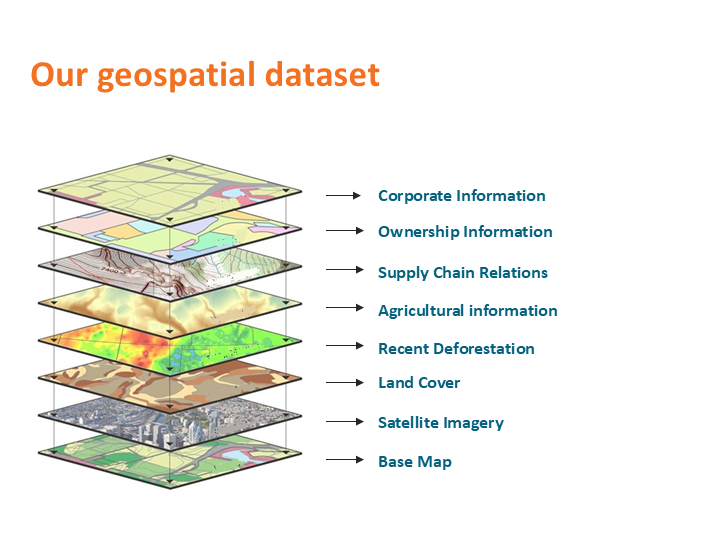
Data used for the development of case studies

For the development of case studies, AidEnvironment relies on the public availability of country-specific data sources. Generally, we rely on our various geospatial datasets developed over many years, typically including cadaster/concession data, company assets, supply chain data, deforestation and fire data, vegetation types (e.g., peatland, wooded savanna). We use among others the JRC Forest Cover 2020 to determine standing forest as of the EUDR cut-off date (31 December 2020). Other than deforestation, we collect data on social issues, including land conflicts, laundering, labour issues, and encroachment in protected and indigenous territories. All social and environmental violations referenced in our reporting should be understood as alleged violations, based on the sources available at the time of publication, and should not be read as final legal findings unless confirmed by a competent authority or court. We validate our case studies with local partners in origin producer countries. For information on reference data sets used per country, please contact AidEnvironment.

We develop most of our cases in Brazil, Indonesia, and various African countries, based on the following specific datasets: In Brazil, AidEnvironment combines geospatial data of rural cadaster systems (CAR, SIGEF, SNCI); company asset infrastructure (warehouses/silos, palm oil mills, slaughterhouses, tanneries), deforestation (e.g. Prodes, MapBiomas), supply chain data (e.g. animal transit data, the so called GTA), fire alerts (NASA), type of vegetation, locations of indigenous territories (e.g. Funai) and protected areas (e.g. Forest Code) to calculate deforestation exposure risk and for the investigation of human rights violations and legality risk.
...

Carbon emissions in Brazil

Only for Brazil, AidEnvironment was able to develop a tool to calculate carbon emissions based on native vegetation type and amount of cleared area. For this, we have assessed “above-ground carbon emissions” according to the cleared vegetation type(s). The tons of carbon emission were calculated per type of vegetation times the ratio of molecular weight of carbon dioxide to carbon (44/12) times the number of hectares cleared.

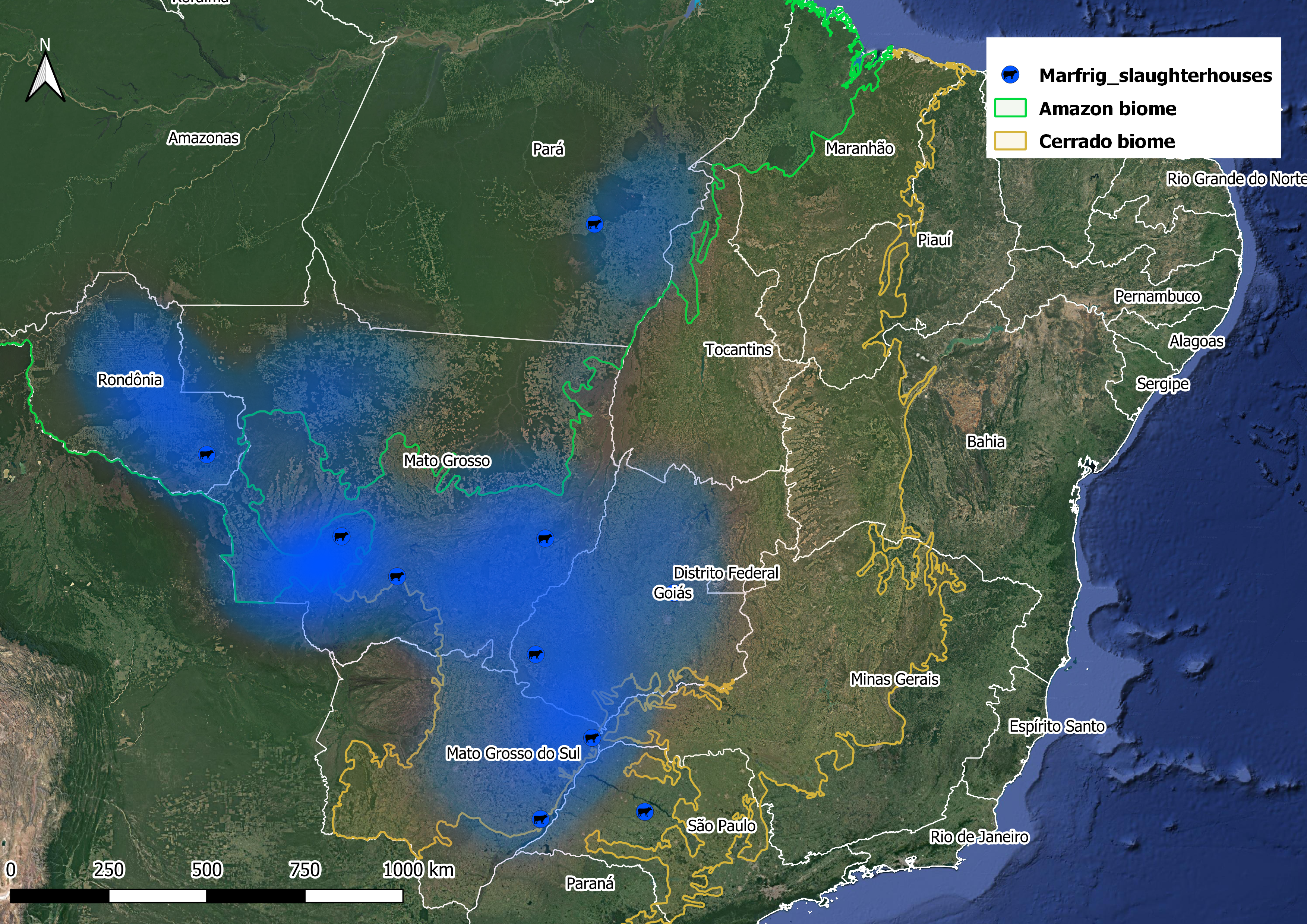
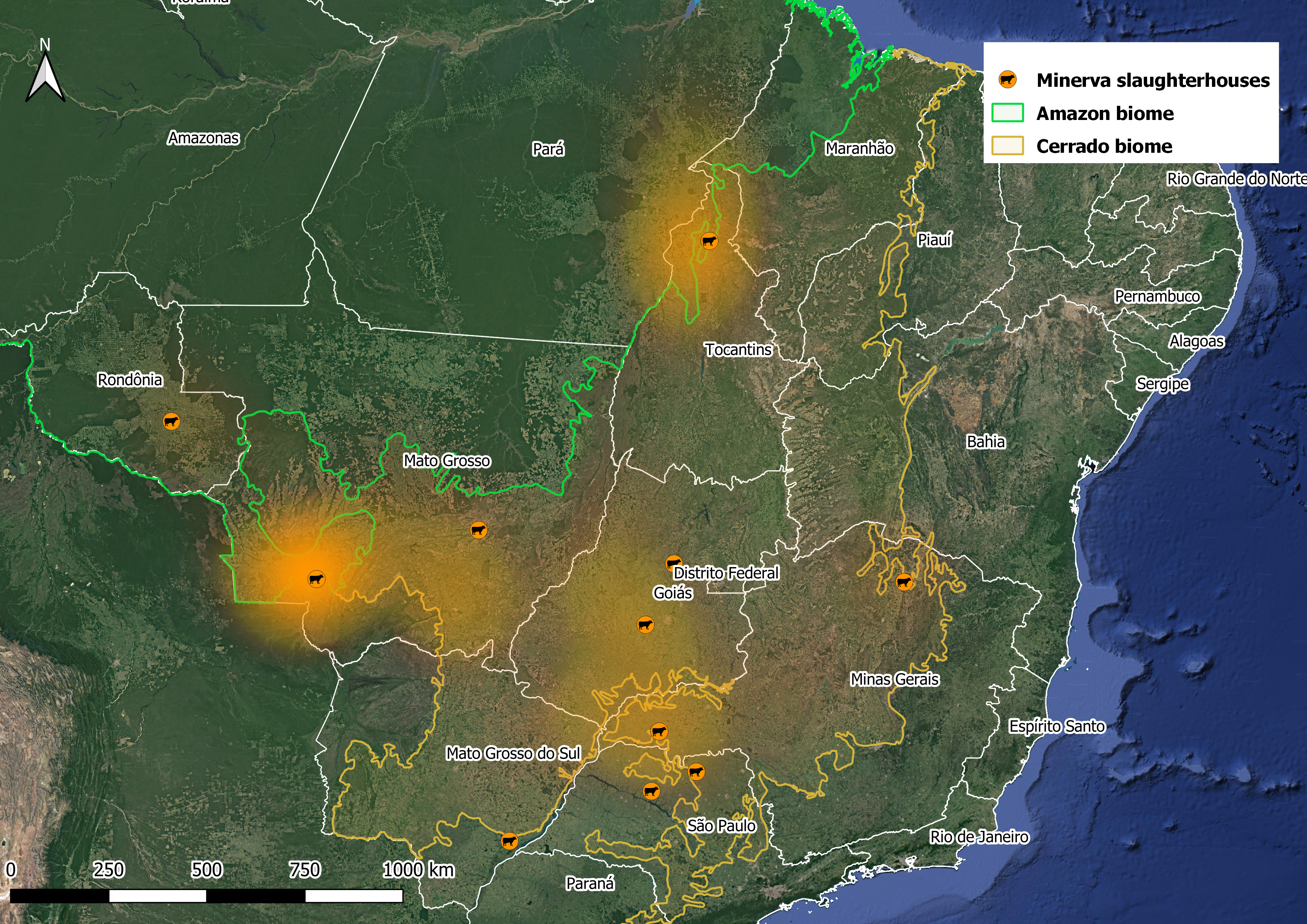
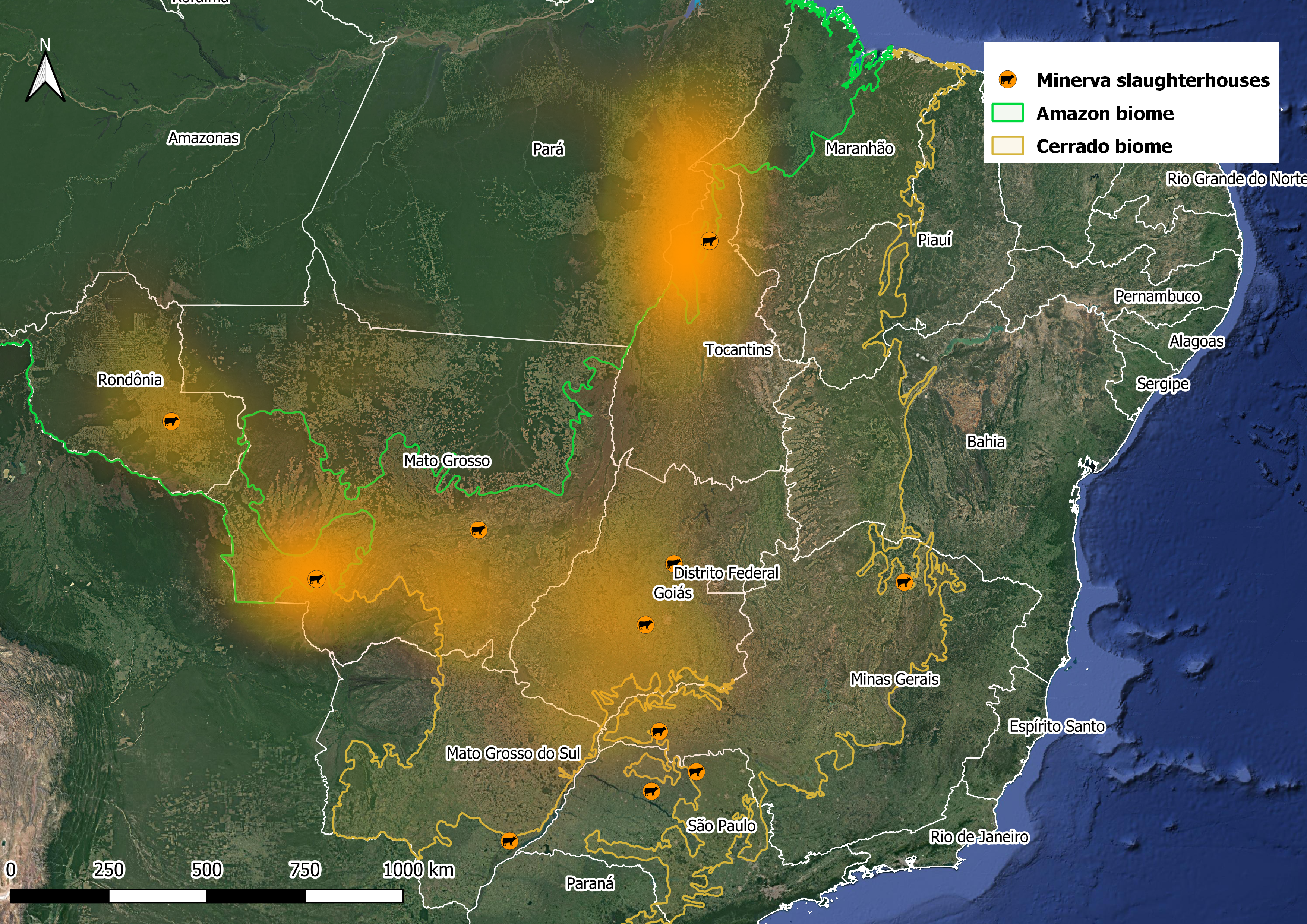
Our sample of direct and indirect suppliers to the largest Brazilian meatpacker companies

AidEnvironment is known to have one of the best datasets on cattle movements combined with farmer cadaster data in Brazil. Currently, we have a sample of 36,441 direct and 103,932 indirect supplying farms to Brazil’s largest meatpackers JBS, Marfrig, and Minerva. AidEnvironment uses this dataset to monitor deforestation and fires within the meatpackers’ supply chains, contributing to Civil Society Organizations campaigns such as Mighty Earth’s Rapid Response and Rainforest Foundation Norway’s leather report, and articles garnering media attention, for instance in The Washington Post and The Guardian.

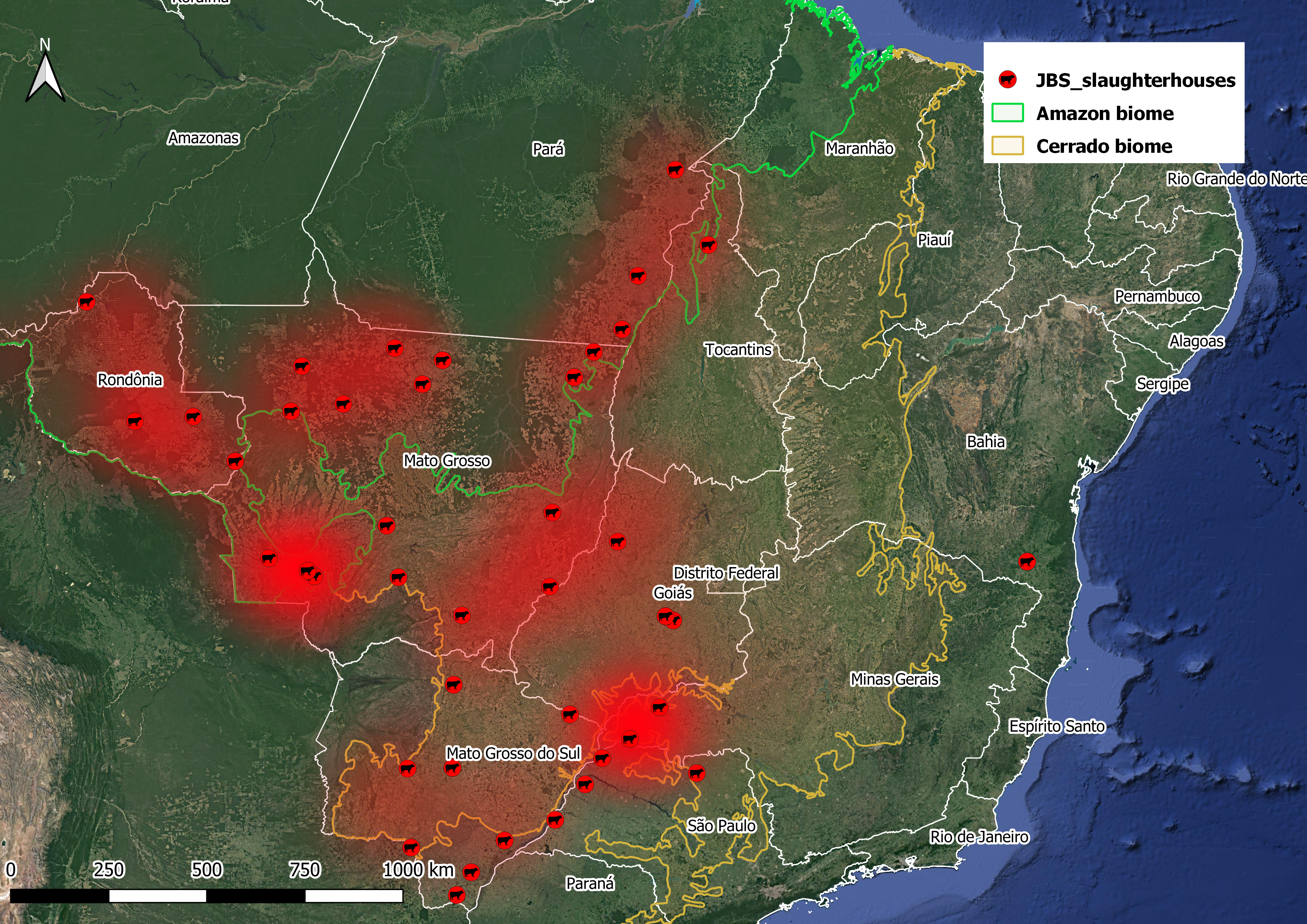
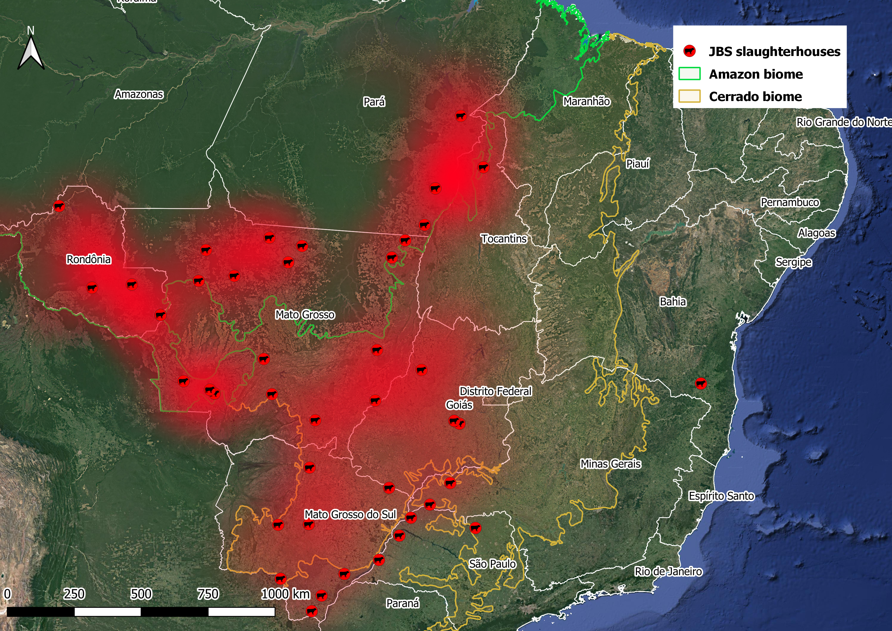
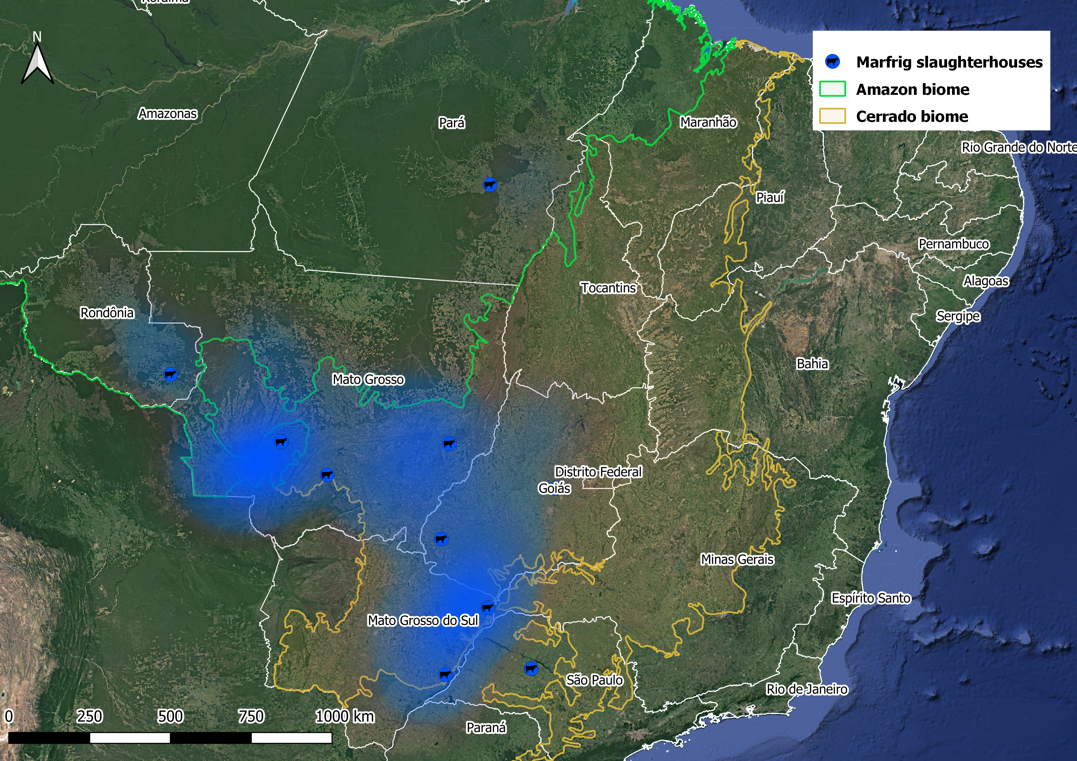
JBS suppliers heatmap – state A JBS suppliers heatmap – state B Marfrig suppliers heatmap – state A Marfrig suppliers heatmap – state B Minerva suppliers heatmap – state A Minerva suppliers heatmap – state B
AidEnvironment’s database covers 36,441 direct and 103,932 indirect supplying farms connected to the three key meatpackers across seven Brazilian states, covering an area of 18.4 million hectares. The brighter the colors, the higher the concentration of direct (images on the left) and indirect suppliers (images on the right) to JBS (red), Minerva (yellow), and Marfrig (blue). — Heatmaps created in QGIS; based on cadaster data from Brazil’s Ministry of Agriculture (SIGSIF) and animal transportation permits (GTA).